Skip to content
Blueprint Travelers
  • Latin America
    • Argentina
    • Bolivia
    • Brazil
    • Chile
    • Colombia
    • Ecuador
    • French Guiana (France)
    • Mexico
    • Panama
    • Paraguay
    • Peru
    • Suriname
    • Uruguay
  • Oceania + Japan
    • Australia
    • New Zealand
    • Japan
  • Resources
    • Itineraries
    • Travel + Hiking Gear Staples
  • Who We Are
    • About Us
    • Work With Us
    • Personal Travel Blog
  • Contact Us
Need help planning your next vacation? Reach out to us and we can help you with your future adventure
Font ResizerAa
Blueprint TravelersBlueprint Travelers
Search your destination or topic...
  • Latin America
    • Argentina
    • Brazil
    • Bolivia
    • Chile
    • Colombia
    • Ecuador
    • French Guiana
    • Mexico
    • Panama
    • Paraguay
    • Peru
    • Suriname
    • Uruguay
  • Oceania + Japan
    • Australia
    • New Zealand
    • Japan
  • Resources
    • All Our Itineraries
    • Travel + Hiking Gear Staples
  • Contact Us
  • About Us
    • Who We Are
    • Work With Us
    • Personal Travel Blog
Follow US
Home > Chile > Santiago Transportation: All Your Options to Get Around the City
ChileSantiago and Valparaiso (Including Easter Island)

Santiago Transportation: All Your Options to Get Around the City

The options for Santiago transportation to best experience and navigate the capital city of Chile and the surrounding area on your next trip.

By
Melina Goldman
ByMelina Goldman
Co-Founder, Editor-in-Chief, Traveler
Experience strategist turned travel writer. Melina has personally researched and visited every destination on this site across Japan, Latin America, Australia and New Zealand.
Follow:
Last updated: March 4, 2026
8 Min Read
This post may contain affiliate links. When you make a purchase using one of these affiliate links, we get paid a small commission at no extra cost to you.
Transportation through Santiago, Chile
Jump to
Walking Around NeighborhoodsSantiago Transportation of the Subway and BusesWhat About Ubers?Other Santiago Transportation Options: Bikes and Scooters

Getting around Santiago can be seen as an organized chaos through an interconnected web. And honestly, Google maps is your best friend. It is completely possible and safe to navigate the city by walking or taking public transportation. And you can also use Uber to get around the city directly and efficiently, especially in the evenings. These are the variety of Santiago transportation options you have to best explore the city.

Santiago transportation options is quite similar to that of Buenos Aires. If you’ve been to one city, you’ll be able to navigate the other. And with Google maps and some urban know-how, you can navigate the city and get around just like the locals!

Walking Around Neighborhoods

A truck going down a cobblestone street with historic buildings with murals - Santiago transportation
Walking through the historical center of Santiago, Chile

The city is large and sprawling and walking is truly only viable within a neighborhood or two. When it comes to safety, it is important to be aware of where you are walking and your surroundings. If you are aware, stay in tourist and commercial neighborhoods, and don’t walk alone through areas that seem abandoned, you will be okay in the city! It is the best way to feel the energy of the city, see the shops and sights, and experience the city. However, consider other means of transportation when getting between neighborhoods, especially Ubers or taxis in the evenings.

As a pedestrian, do not expect any vehicles to yield for you to cross the street and make sure to look both ways on one-ways for any bikes. Cars and buses travel fast and brake hard, but it won’t be hard enough to save you, so make sure to keep your head on a swivel!

You can check out various hotels for Santiago here.

Santiago Transportation of the Subway and Buses

The main option with regards to Santiago transportation is public transportation. Using the subway or buses is the most economical and sustainable way to navigate large distances throughout the city. The Santiago transportation system is extensive, including buses and a subway system. Both of these are safe and great ways to get between neighborhoods or traveling in the evenings. You will also find that the public transportation systems are clean. People have a lot of pride in these systems.

To use Santiago transportation, you need to obtain a “Red” card. You can buy them at subway stations with cash only. The card costs a flat fee but you don’t have to pay any additional fees to load money on the card. Overall, rides with the “Red” card will be a about 50 cents!

The Subway

People getting on and off a subway train in a station - Santiago transportation
Santiago's subway system

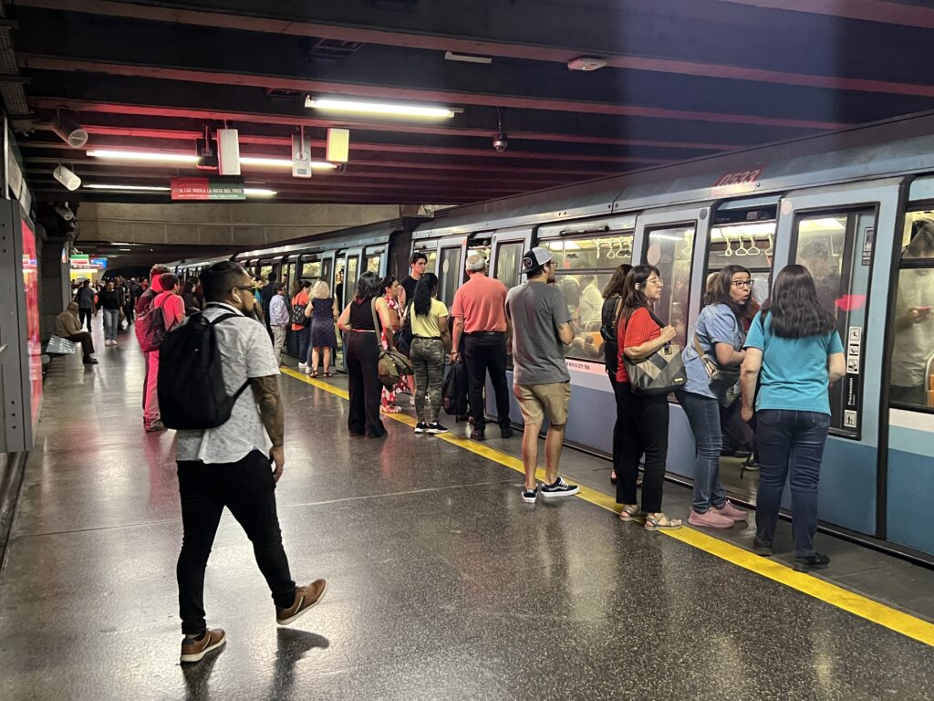
The subway is a fast and efficient way to navigate Santiago. The first line of the system was opened in 1975 and it continues to be a reliable form of transportation within the city. Most of the time, you will not wait more than a few minutes for a train. If Google Maps shows the subway as an option to get between two places, use it! The system operates between 6 AM (Monday – Saturday) or 8 AM (Sunday) and midnight so keep that in mind if going out in the city. 

The Buses

The network of buses is large. Chances are, there are a number of bus stops around your hotel or accommodations within Santiago. Use Google Maps to determine the best route. The bus stops are indicated by a bench and overhang or a number on a pole. The buses are a great way to see the city and explore the urban environment, all while getting around Santiago. There are a couple of things you need to know to best use the buses while visiting Santiago:

The interior of a public bus - Santiago transportation
A typical bus in Santiago, Chile
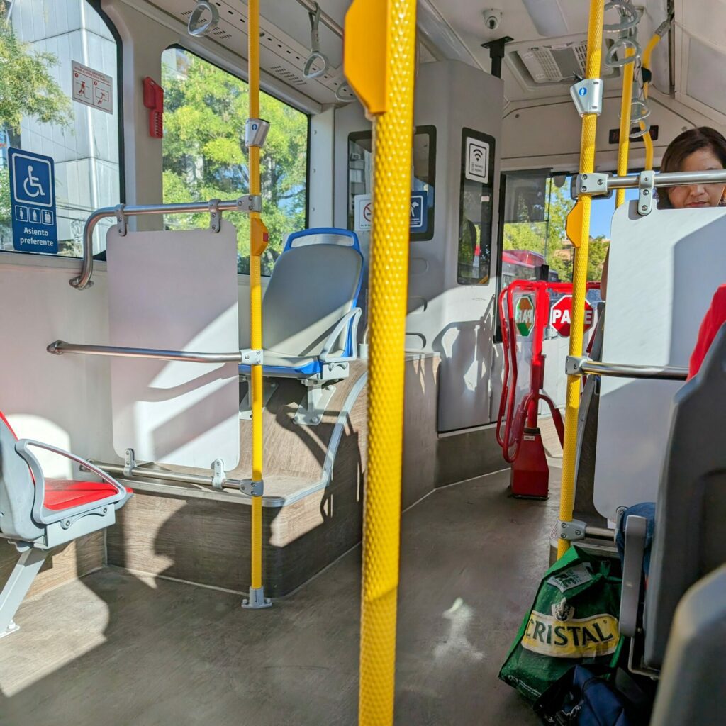
  1. You can see what bus is arriving by the number displayed on the top of the bus. 
  2. Once the bus stops, get on the bus as quickly as possible because the bus driver will be itching to leave the stop. You will scan your card against the card reader until it gives you the green light and go through the turnstile to find a seat or stand if the bus is full.
  3. To get off the bus, make your way towards the middle or back doors and press the button on the pole by the doors. The bus driver will not stop unless you press the button to indicate that you want to get off at the next stop.

What About Ubers?

The city has a lot of Ubers and it is a really easy way to get around, especially if you are nervous about getting from place to place or it is later in the evening. Typically, you will not have to wait very long for a car and it is similar in price to a taxi. Ubers are efficient and eliminate the requirement of having to explain to a taxi driver what your destination is, especially if you do not speak Spanish. It is recommended to use Uber in the evenings and to get to and from the airport or main bus stations, especially with all your luggage. 

Other Santiago Transportation Options: Bikes and Scooters

Scooters lined up on a sidewalk - Santiago transportation
Scooters at a park in Santiago, Chile

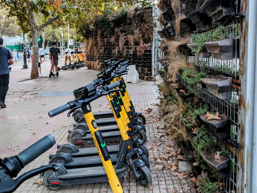
You may see some orange bikes around the city. These are the local shared bike service. However, you will need to download the application (linked here) and create an account. You will need data to use the app to take out a bike. Some areas of the city have bike lanes and there is an effort to make the city more biker friendly. 

In addition to the bikes, there are some areas that are equipped with “Lime” and other brands of scooters. You will also need applications to use these but they could be nice way to explore the park areas of the city. Check out the scooter brands that are around your hotel and download those applications for your next ride around the city. 

some of the Other Things to Consider to Visit Santiago?

The various things to do in Santiago

Read more about the Blueprint Travelers personal experience in Santiago

Share This Article
Facebook LinkedIn Copy Link
ByMelina Goldman
Co-Founder, Editor-in-Chief, Traveler
Follow:
Experience strategist turned travel writer. Melina has personally researched and visited every destination on this site across Japan, Latin America, Australia and New Zealand.
  • General Info
  • Local Food and Drinks
  • Local Dining Recommendations
Contents
Walking Around NeighborhoodsSantiago Transportation of the Subway and BusesWhat About Ubers?Other Santiago Transportation Options: Bikes and Scooters

You Might Also Like

A landscape of geysers with the sun rising over the mountains behind - San Pedro de Atacama desert itinerary
Chile

The Best Things to Do for a San Pedro de Atacama Desert Itinerary

A sun setting over a rocky dock with palm trees - Easter Island itinerary
Chile

The Ultimate Easter Island Itinerary: 6 Days in Chilean Polynesia

A person on a boat on a lake in front of volcanos and mountains - Cruce Andino
Chile

Cruce Andino: How to Cross Between Chile and Bariloche by Land

The view overlooking a grassy area leading to the ocean with some statues on the edge of the land - How to visit Easter Island
Chile

How to Visit Easter Island and Other FAQs You Have

First-hand guides from real travelers

Blueprint Travelers was founded by Kevin and Melina, two travelers who have personally visited every destination on this site across Japan, Latin America, Australia and New Zealand. Every guide starts with extensive research through guidebooks, travel blogs, and specialist resources, then conversations with locals and tourism centres, then the trip itself. Nothing makes it onto the page until it has been tested firsthand.

meet Melina and Kevin →

Need help planning your trip?

Not sure where to start? Reach out directly. Kevin and Melina love helping travelers structure itineraries, choose the right destinations for their time and budget, and find the experiences that will actually matter.

Get in touch →

Every destination we cover

Latin America

Argentina

Bolivia

Brazil

Chile

Colombia

Ecuador

French Guiana (France)

Mexico

Panama

Paraguay

Peru

Uruguay

Suriname

Oceania

Australia

New Zealand

Asia

Japan

Popular Starting Points

All Itineraries →

Australia highlights →

New Zealand highlights →

Mexico City travel guide →

Tokyo first-time guide →

Patagonia travel guide →

Destination inspiration on your Instagram feed

🚀👩‍🚀🔭🪐 The Guiana Space Center is the crown jewel 🚀👩‍🚀🔭🪐 The Guiana Space Center is the crown jewel of French Guiana (a French territory that is part of the Guyanas region in South America) and a remarkable place to visit, especially for those who are interested in space and the future of space travel.  The Guiana Space Centre is the official space center for all of Europe and is an important facility to maintain space independence by the countries of Europe. This location was chosen after France lost their territory of Algeria, where the prior space center was located. It is an ideal space center location because it is located near the ocean, away from large population centers, and in a seismic and hurricane free zone.  The most unique aspect of this space center is that you can actually take a free guided tour by bus to different facilities around the sprawling site. This tour may visit two different command centers and the location where the rockets are assembled. It is the only place in the world where you will have such access to launch pads and command centers.  You can learn more about visiting the space center and French Guiana on our website. 🔗 Link is in the bio.  #guianaspacecenter #frenchguianatravelguide #southamericatravelexpert #frenchguiana #spacecentertour
The Northland region of New Zealand is the norther The Northland region of New Zealand is the northernmost area of the country known for its important cultural sites, long beaches, and beautiful coast line. With so many things to do in Northland, you could easily spend four days exploring the region to experience this incredible part of the country.  🛟 Save this post for your next trip to the Northland region of New Zealand! And you can always read more on our website, 🔗 linked in bio.  📍Northland, North Island, New Zealand  #northlandnewzealand #newzealanditinerary #newzealandtravel #northislandnz #newzealandtravelguide
Auckland is New Zealand’s largest city and its eco Auckland is New Zealand’s largest city and its economic center, with a noticeably more international feel than the rest of the country. Maungawhau / Mt Eden (pictured) is a site of cultural significance to Māori, believed to have once been guarded by a deity living within the crater. A boardwalk now circles the cone, offering 360° views across Auckland and a clear look at the city below.  📍Auckland, North Island, New Zealand  #NewZealandTravel #AucklandNZ #CulturalTravel #MeaningfulTravel #travelphotography
Follow on Instagram

New guides monthly straight to you

Kevin and Melina publish fresh itineraries, deep dives, and honest travel advice in a newsletter about once a month. No spam, no filler. Just the guides you would actually use.

Blueprint Travelers

First-hand travel guides for Latin America, Australia, New Zealand and Japan, written by expert travelers who have actually been there.

instagram
Pinterest
Linkedin
facebook

Travel Destinations

Argentina

Australia

Bolivia

Brazil

Chile

Colombia

Ecuador

French Guiana (France)

Japan

Mexico

New Zealand

Paraguay

Peru

Uruguay

Suriname

All Destinations →

More

All Itineraries

Travel + Hiking Gear Staples

Who We Are

Work With Us

Personal Travel Blog

Social Media Links

Copyright © 2026 Blueprint Travelers LLC. All rights reserved. No part of this site may be reproduced without our written permission.
  • Privacy Policy
  • Disclosure Policy
  • Blueprint Travelers – Terms of Use
Welcome Back!

Sign in to your account

Username or Email Address
Password

Lost your password?